BEAVERTAIL RECREATION SITE
OPEN: memorial day- labor day
FEES: $8-12 dollars (depending on season and the type of permit you want)
AMENITIES: pit toilets, picnic tables, swimming
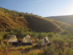
Right along the Deschutes River, Beavertail Rec Site is a great spot for casual car camping. There are 17 site nestled in amongst sage-brush and juniper trees in high desert BLM land. Despite the size of the site, it isn't super busy as it's fairly far down a windy road that takes you past a dozen similar campsites all along the river. You could probably choose any of them and have a similar experience! The river runs through a ravine and the hills above are golden and rolling. They make a great border for star gazing at night too!
FEES: $8-12 dollars (depending on season and the type of permit you want)
AMENITIES: pit toilets, picnic tables, swimming
Right along the Deschutes River, Beavertail Rec Site is a great spot for casual car camping. There are 17 site nestled in amongst sage-brush and juniper trees in high desert BLM land. Despite the size of the site, it isn't super busy as it's fairly far down a windy road that takes you past a dozen similar campsites all along the river. You could probably choose any of them and have a similar experience! The river runs through a ravine and the hills above are golden and rolling. They make a great border for star gazing at night too!


Directions: From The Dalles (i-84) turn south on Highway 197 for about 30 miles. Turn left onto Highway 216 (Sharar's Bridge Highway). Right after you cross the bridge, take a left down a dusty road and follow it for a looonnngg time until you see Beavertail Rec Site. As mentioned, there are plenty of other sites along this road if you don't want to drive all the way to Beavertail!
Helpful Links: BLM site
Helpful Links: BLM site
SQUARE LAKE & BOOTH LAKE

south square lake
campsite
OPEN: year-round (be prepared for snow and cold in the winter and spring though...probably not the best time for camping.)
FEES: Northwest Forest Pass required, $5.00/day, $30.00/annual pass. Available at trailhead.
AMENITIES: outhouse, picnic table, and garbage can in parking lot, swimming
Square Lake and Booth Lake are a part of the Mt Jefferson Wilderness, just south of Three Fingered Jack in Linn County. From the parking lot, it's about 2.5 miles to Square Lake and another 1 or 2 miles from there up to Booth Lake. There are camping spots at both. The area seems to be somewhat unpopular. We were here mid-week in early July and didn't see a single other person on the trail and no one at either lake. (We did see a few people hiking in the next morning as we were hiking out. Most seemed to be day-hikers, and only a couple of them looked to be back-packing.)
There was a forest fire here in 2003, so there is not a lot of forest cover. This offers great views of Mt Washington, Black Butte, the Sisters, and Three Fingered Jack. As you hike in you're surrounded by soot-black and silvery spires: the remnants of the firs and pines that once stood here. There is plenty of foliage that has grown up since then though. We highly recommend going in summer as you'll be surrounded by bright and fragrant flowers: larkspur, lilies, bear grass, columbine, penstemon, and loads of what we were calling mountain laurel (we couldn't determine what this shrub actually was, but it grew everywhere, had wonderfully perfumed flowers, and the bees loved it!).
Once you get to Square Lake you have a few options: Follow the trail along the west side of the lake until it curves around on the north side. There you'll find a nice big campsite, slightly shaded, with easy access to the water. Other options include bushwhacking your way down to the lake as you come to it on the south side. There are some (almost non-existent) deer trails along the bank of the lake, and an ancient forgotten camp site on that side. There are photos of the different sites below, and you can enlarge them and read the descriptions to see which ones are which. The water is quite warm and clear. Lovely for a swim after a sweaty hike!
You can also continue another 1 1/2 or 2 miles up to Booth Lake. On the north side of Square Lake, you'll take a left at a clearly marked trail which leads you up a slope. It's not super steep, but you do gain some elevation. Booth Lake is a bit smaller, but just as beautiful and just as refreshing!
One note: the mosquitoes here were killer! They still were voracious even through a layer of deet, clothes, and more deet. Annoying, but worth it! Aside from the bugs there is not a lot of wildlife, although we hung our food away from the tent just in case.


Directions: from Highway 20/126 turn North on a clearly marked road to the Pacific Crest Trail. (About 20 minutes from Sisters if you're coming from the East, and just a few miles past the junction of 20 and 22 if you're coming from the west.) Follow half a mile up to the parking lot. Find the Pacific Crest Trail on the south side of the parking lot. Follow it for about half a mile and take a right on the clearly marked Summit Trail (though it doesn't mention either lake). This runs parallel to the road for a while before curving north taking you over the hill to Square Lake!
JOHN DAY RIVER (NEAR PAINTED HILLS)

OPEN: All year (to my knowledge)
FEE: none
AMENITIES: picnic table, John Day River
For years I wanted to go to the Painted Hills near Mitchell, OR but was unsure about the camping situation out there. Recently, I researched a little further and found some spots that are available on the John Day River within 10 miles of the Hills. We ended up going to the Lower Burnt Ranch area for camping. After driving down the Lower Burnt Ranch Road a few miles, you pass a home that has a lot of cattle and a nice stack of animal skulls against their shed. Shortly past this house you'll notice a sign for a boat launch on the right and a dirt road. This launch was closed for boats and is where we ended up camping for the night. I am not sure if it is permanently closed or just seasonally. In the case it is not closed for boats, there are other camp sites in the area. Please refer to the link below for BLM Camping Areas.
There is a point on the short dirt road where you can drive no further as the road is blocked by a metal barracade. You can park here and walk the rest of the way. It is only a few hundred yards. The clearing in this spot was huge and mostly flat. When the river is high, it is probably under water. The ground is a little rocky but even with that, easy to find a good place to throw a tent, or more, out for some good camping. There is a small tree with a picnic table under it. I climbed up the hill to the left facing the river for a nice view looking down on the site and the amazing rock formations nearby. There is a picture below shot from this vantage point.
This is a great spot to spend some time! I am sure the water is great to get in during the summer, yet there are a lot of cattle near, so consider the run-off.
If you search directions to the Painted Hills, Wheeler, OR the directions will get you most of the way there. Look north on the map until to see the John Day River and you will get an idea of where you will be heading.


Directions: From Portland take 26 east to Bridge Creek Road (this is well past Prineville). Bridge Creek turns into Burt Ranch Road. Stay on this road past the turn for the Painted Hills (Bear Creek Road). You will pass a sign for a few campgrounds in the area (Priest Hold being the closest). Keep following the road. Eventually it will turn and force you heading West. Continue past the cattle ranch with the animal skull pile and in a short distance (less than 2 miles) you will see a dirt road on the right with a sign for the boat launch.
Helpful Links: BLM Campsites, Mitchell Oregon
Helpful Links: BLM Campsites, Mitchell Oregon
SMITH ROCK

OPEN: All year
FEE: $5.00 per person per night
AMENITIES: bathrooms, showers, picnic tables in designated area
Smith Rock is mostly known for rock climbing, but it has much more to offer. This campground is a walk-in "bivouac area" which means that it never fills up. You can pitch your tent anywhere in this area but most cleared spots start about 200 yards from the parking lot. Yet, there is prime real estate here. We have been fortunate enough to find sites at the far edge of the campground, furthest from the parking lot, overlooking the steep, rocky hillside as well as the Crooked River and facing the monolithic Smith Rock. There are no fires in the camping area so you have to return to a designated area in the center of the parking lot to use a stove to cook. That said, we see this as a great compromise between backpacking and car camping.
There are hiking trails that encircle the rock formations at Smith Rock and some that hug closely to the river. These trails vary in difficulty. One trail circles around the far west side of the rocks and is flat and easy. You can make it a loop by hiking up to Monkey Face and then back down via Misery Ridge. It's a steep climb, but the view is worth it. This loop is about three miles.
There are plenty of spur trails that lead up to the rock face where you can do some good exploring and hopping around on boulders. Especially up at Asterisk Pass.
Another thing we love about this place is the sage growing everywhere. It smells wonderful and we always collect some to dry and take home with us.


Directions: From Portland take 26 east. Continue onto US-97 S/The Dalles-California Hwy until you reach the town of Terrebonne. Turn left onto B Ave. Continue to follow Smith Rock Way. Left onto 17th Turn right onto Lambert Rd/NE Wilcox St. 1st left onto Crooked River Drive
Helpful Links: Smith Rock State Park Site
Helpful Links: Smith Rock State Park Site
